
Coordinate System
Pronunciation: /koʊˈɔr.dnɪt ˈsɪs.təm/ ExplainA coordinate system is a metric geometry (a geometry where distance can be measured) where the location of a point is identified by one or more coordinates.[2] The coordinates of a point is a set of numbers that indicate a position relative to an origin. In a coordinate system, points can be plotted and graphs can be made. In a coordinate system, visual representation of equations and other mathematical objects can be created. Two of the most commonly used coordinate systems are the Cartesian coordinate system and the polar coordinate system.
Cartesian Coordinate System
|
Click on the blue point and drag it to see the coordinates of various places in the graph. Where are the coordinates (0,0)? Where are the coordinates (-2,1)? Where are the coordinates (0,-1)? |
| Manipulative 1 - Cartesian Coordinates Created with GeoGebra. |
The most commonly used coordinate system is the Cartesian coordinate system.[4][5] It is named after French mathematician René Descartes, who formalized the concepts of coordinate systems in his book, La Géométrie. A Cartesian coordinate system can also be called a rectangular coordinate system.
In a 2-dimensional Cartesian coordinate system, there are 2 axes set in a plane. One axis is vertical and the other axis is horizontal. The plane is called a Cartesian plane or coordinate plane. The horizontal axis is usually called the x-axis and the vertical axis is usually called the y-axis The point where the two axes intersect is called the origin. To make discussion easier, the coordinate plane is divided into four quarters, each called a quadrant. The upper-right quadrant is called Quadrant I, the upper left quadrant is called Quadrant II, the lower left quadrant is called Quadrant III, and the lower right quadrant is called Quadrant IV.
Corresponding to the x-axis and y-axis is an ordered pair of numbers that is the coordinates. The coordinates tell the location of a point. For example, in the ordered pair of numbers (x0,y0), x0 tells the distance from the origin parallel to the x-axis and is called the x-coordinate. y0 tells the distance from the origin parallel to the x-axis and is called the y-coordinate.
To plot a point such as (1,1), start from the origin, then move 1 unit to the right (positive direction) along the x-axis, and 1 unit up parallel to the y-axis. See figure 1.
Polar Coordinate System
|
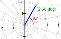
In a polar coordinate system the location of a point is defined by an angle, and a radius or magnitude.[5] To plot the point (2,60°), find the rotation of 60°, then move 2 units out from the origin. See figure 2. |
Word Processing and Publishing
|
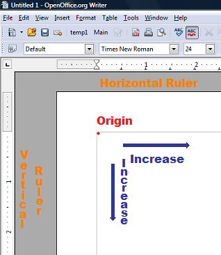
Word processing programs use a coordinate system with the origin in the upper left hand corner for languages that are read from left to right. The horizontal coordinate increases to the right. The vertical coordinate increase downwards. Figure 1 shows the coordinate system in Open Office Writer 3.2.0. For languages that are read from right to left, the origin is on the right and the horizontal increase goes from right to left. In publishing, the unit for the horizontal and vertical axes are picas. Each pica measures 1/6th of an inch. |
References
- McAdams, David E.. All Math Words Dictionary, coordinate system. 2nd Classroom edition 20150108-4799968. pg 47. Life is a Story Problem LLC. January 8, 2015. Buy the book
- coordinate system. merriam-webster.com. Encyclopedia Britannica. Merriam-Webster. Last Accessed 6/25/2018. http://www.merriam-webster.com/dictionary/coordinate system. Buy the book
- Bettinger, Alvin K. and Englund, John A.. Algebra and Trigonometry. pp 49-50. www.archive.org. International Textbook Company. January 1963. Last Accessed 6/25/2018. http://www.archive.org/stream/algebraandtrigon033520mbp#page/n66/mode/1up/search/coordinate. Buy the book
- Underwood, Ralph S.; Nelson, Thomas R.; Selby, Samuel S.. Intermediate Algebra. pp 90-93. www.archive.org. The Macmillan Company. 1947. Last Accessed 6/25/2018. http://www.archive.org/stream/intermediatealge033585mbp#page/n101/mode/1up/search/coordinate. Buy the book
- Fuller, Gordon. Analytic Geometry. pp 120-140. www.archive.org. Addison-Wesley Publishing Company, Inc.. 1954. Last Accessed 6/25/2018. http://www.archive.org/stream/analyticgeometry033542mbp#page/n135/mode/1up/search/polar. Buy the book
- Descartes, René. La géométrie. Translated by A. Hermann. www.archive.org. Librarie Scientifique. 1886. Last Accessed 6/25/2018. http://www.archive.org/stream/lagomtrie00descuoft#page/n8/mode/1up. Buy the book
Cite this article as:
McAdams, David E. Coordinate System. 3/9/2019. All Math Words Encyclopedia. Life is a Story Problem LLC. https://www.allmathwords.org/en/c/coordinatesystem.html.Image Credits
- All images and manipulatives are by David McAdams unless otherwise stated. All images by David McAdams are Copyright © Life is a Story Problem LLC and are licensed under a Creative Commons Attribution-ShareAlike 4.0 International License.
Revision History
12/21/2018: Reviewed and corrected IPA pronunication. (McAdams, David E.)6/25/2018: Removed broken links, updated license, implemented new markup, updated GeoGebra apps. (McAdams, David E.)
3/15/2010: Improved manipulative, added quadrants, added "Word Processing and Publishing". (McAdams, David E.)
1/5/2010: Added "References". (McAdams, David E.)
7/10/2008: Expanded first paragraph. (McAdams, David E.)
7/7/2008: Corrected spelling. (McAdams, David E.)
4/30/2008: Initial version. (McAdams, David E.)
- Navigation
- Home
- Contents
-
# A B C D E F G H I J K L M N O P Q R S T U V W X Y Z - Teacher Aids
- Classroom Demos
- How To
- LIASP
- LIASP Home
- Conditions of Use
- Privacy Policy
- Donate to LIASP
- Help build this site
- About LIASP
- Contact LIASP
All Math Words Encyclopedia is a service of
Life is a Story Problem LLC.
Copyright © 2018 Life is a Story Problem LLC. All rights reserved.
This work is licensed under a Creative Commons Attribution-ShareAlike 4.0 International License